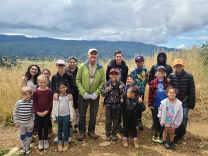
It is widely recognized that more scientific outreach and STEM education is needed in our society. Maps offer a unique visual bridge to address this need. For millennia humans have combined their cognitive-spatial intelligence with graphics to create maps. Some researchers believe that maps may predate writing. Geologic maps add additional layers of information on the rocks and their structure that are displayed in a spatial manner. Information about the earth is relayed in a more universal manner that commonly relies more on symbols than text. With time a student will appreciate the earth-history story told by a map, further creating an interest in the earth sciences and potentially other scientific disciplines. More generally, map proficient students will learn a useful skill that broadens their knowledge of the outdoors and science.
Many adults, teens, and older children find geologic maps interesting and colorful even if they do not fully understand the information conveyed. Perhaps a map indicates the presence of gold and silver, even oil deposits, or an earthquake fault, but shown in some mysterious way only discernable to a trained geologist. By and large, the public do not appreciate the complete language of geologic maps that are standardized and easily taught to individuals over 7 or 8 years of age. Students of geologic maps learn more than how to read a map. They learn earth history, more about the science of geology and earth processes. Many geologic concepts rely on basic chemistry, physics and biology, and geology is widely recognized as a more qualitative means of broadly teaching STEM. This can be seen at many universities and colleges where introductory geology courses are very popular and commonly serve as the physical science requirement for liberal arts majors.
Additional educational accomplishments: GMF authored The Geology of Santa Cruz Island, California,
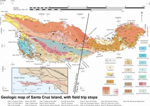
published by the Geologic Society of America: https://pubs.geoscienceworld.org/gsa/books/edited-volume/2279/chapter-abstract/126263829/Santa-Cruz-Island-field-trip-Geology-history-and

Thomas L. Davis, PhD, President and Director. California Professional Geologist #4171
Davis is a California State registered geologist and an author on a number of geologic publications-especially dealing with the structural geology and petroleum potential of California. Davis has worked as a consultant and researcher worldwide, for numerous public and private energy companies, several national oil companies, the United States Geological Survey (USGS), Southern California Gas Company, and the Playa Vista development in the Los Angeles basin. Formerly Davis was a partner in Davis & Namson Consulting Geologists, and prior worked for the Atlantic-Richfield Corporation.

David Kimbrough, PhD, Vice-President and Director. Professor of Geology, California State University San Diego
Dr. Kimbrough completed his PhD at UCSB (on geology of Cedros Island, Baja California) and served as a SDSU faculty member since 1989. He has led research and education efforts in the circum-Pacific region (Antarctica, New Zealand, Australia, Japan, Canada, Mexico, South America) supported mainly by NSF grants.

Monica Davis, MBA, Treasurer and Director. Chief Operating Officer of Mental Health America of Los Angeles (MHALA)
Monica Davis, MBA is the Chief Administrative and Contracts Officer for Mental Health America of Los Angeles. She has spent 20+ years working in the public mental health system, performing roles of outcomes collection and analysis, business operations, finance, and county contracting. From 2001 – 2007, Monica was the coordinator of the department that collected, analyzed, and reported the statewide data that was used to advocate for the Mental Health Services Act.

Lindsey Hronek, Secretary and Director. PhD Student West Virginia University
Lindsey Hronek has worked at Thomas L. Davis Geologist for ten years doing administration, book-keeping, drafting, and GIS assignments. Lindsey is also working on her PhD in Behavior Analysis at the West Virginia University.